Best Lidar Systems for Drones: Enhance Sensing, Navigation, and Safety
The growing integration of LiDAR sensors into drones offers higher accuracy for obstacle avoidance, altitude hold, and mapping. This article highlights five Amazon-listed products that showcase LiDAR or LiDAR-enabled sensing in drone applications, from ready-to-fly aircraft with 360° obstacle detection to standalone LiDAR rangefinders for DIY projects. Explore options that balance range, speed, and integration ease for American hobbyists and professionals alike.
| Product | Primary LiDAR Feature | Use Case |
|---|---|---|
| DCX Volo X EZ AI Drones | 360° Obstacle Avoidance with LiDAR sensing | Beginner-friendly aerial photography with automatic safety features |
| Benewake TF02-Pro LiDAR Sensor | 40 m range, high accuracy, 1000 Hz | Real-time distance measurement for UAVs and smart systems |
| MakerFocus TF-Luna LiDAR Range Finder | 0.2–8 m range, TOF LiDAR | Single-point distance sensing for microcontrollers and drones |
| TF-Luna LiDAR Range Finder Sensor (0.2–8 m) | UART/I2C interface, compact robotics sensor | Integrates with Pixhawk, Raspberry Pi, and Arduinos |
| DJI Mini 5 Pro Fly More Combo | Omnidirectional obstacle sensing (vision-based) | Compact professional drone with advanced sensing |
DCX Volo X EZ AI Drones

- Brand: UNLIMITED
- 4K camera and AI-assisted flight control
- 360° obstacle avoidance with LiDAR sensors for safer navigation
- FAA Remote ID compliant and beginner-friendly
- Automatic Precision Return-to-Home for safe landings
The DCX Volo X EZ integrates LiDAR-enabled sensing into a ready-to-fly platform designed for users seeking easy aerial captures without compromising safety. Its 360° obstacle detection helps pilots maintain stable routes in cluttered environments, while AI-assisted features simplify operation for beginners. Users should note the initial step of removing camera padding to avoid restricting gimbal movement. The drone’s safety-centric design positions it as a practical entry point for LiDAR-equipped flight in consumer markets.
Benewake TF02-Pro LiDAR Sensor

- Brand: Benewake
- IP65 protection rating for robust field use
- Distance range: 0.05 m to 40 m (high reflectivity), up to 13.5 m at low reflectivity
- High accuracy: ±5 cm (0.05–5 m), ±1% (5–40 m)
- Ultrafast frame rate up to 1000 Hz for real-time monitoring
The TF02-Pro is a high-performance LiDAR sensor designed for UAVs and automation systems requiring accurate distance measurements across a broad range. Its fast response supports dynamic obstacle avoidance and precise altitude estimation. The IP65 rating ensures resistance to dust and water jets, making it suitable for outdoor drone applications. Integrators should consider mounting and power supply requirements when embedding this sensor into DIY or professional builds.
MakerFocus TF-Luna LiDAR Range Finder

- Brand: MakerFocus
- Single-point LiDAR ranging from 0.2 to 8 m
- TOF principle with stable, accurate distance measurement
- Configurable parameters for different environments; supports UART/I2C
- Compact and affordable option for microcontroller projects
TF-Luna from MakerFocus offers a compact LiDAR solution tailored for drones and robotics projects needing straightforward distance sensing. Its simple single-point ranging makes it ideal for altitude hold, obstacle sensing, and integration with Pixhawk, Arduino, or Raspberry Pi platforms. The module emphasizes cost efficiency without sacrificing core accuracy, though users should account for its narrow field of view and TOF-based measurement in dynamic scenes.
TF-Luna LiDAR Range Finder Sensor 0.2m-8m

- Brand: Wishiot Store
- Operating range: 0.2–8 m; 1 cm resolution
- Low power consumption; 5V supply
- Frame rate up to 250 Hz; 2-degree FOV
- UART/I2C interface; compatible with Raspberry Pi Pico, Pixhawk, and more
The TF-Luna module from Wishiot Store is a compact LiDAR solution optimized for hobbyist drones and embedded systems. It provides precise distance readings in a small package, with UART and I2C interfaces supporting popular flight controllers. Its light footprint and low power usage make it suitable for small UAVs, though its limited range should be matched to the drone’s mission profile and required sensing distance.
DJI Mini 5 Pro Fly More Combo
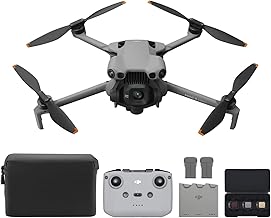
- Brand: DJI Store
- 1-Inch CMOS sensor; 4K video at 60fps
- Ultra-light, foldable design with compact form factor
- Omnidirectional obstacle sensing and ActiveTrack 360°
- Includes three batteries and DJI RC-N3 remote
The DJI Mini 5 Pro delivers a refined balance of camera capability and sensor suite in a compact frame. While not a dedicated LiDAR system, its omnidirectional obstacle sensing combines computer vision and sensing technologies to provide robust collision avoidance. The drone’s 1-inch camera and advanced gimbal features enable professional-style footage in a small form factor suitable for travel and on-site surveying. Users seeking LiDAR-grade performance may pair it with external sensing modules where feasible.
Buying Guide: LiDAR for Drones
- Range and resolution: Higher range and finer resolution improve obstacle detection and mapping, especially in open or fast-moving environments. Balance range with sensor footprint and power consumption.
- Interface and compatibility: Ensure LiDAR modules support UART/I2C or SPI and are compatible with your flight controller (Pixhawk, ArduPilot, or DJI controllers) and processing boards (Raspberry Pi, Arduino).
- Mounting and integration: Consider sensor placement to minimize blind spots and ensure clean air flow. IP ratings (like IP65) help with outdoor reliability; shield cables and secure mounts to reduce vibration.
- Synchronization with flight control: Real-time data latency matters for obstacle avoidance and landing. Higher Hz ratings (e.g., 1000 Hz) enable faster reaction times, but require more processing power.
- Power and weight: LiDAR modules add weight and power demand. Assess total payload capacity and flight time budget when selecting a sensor.
- Application fit: For autonomous mapping, higher accuracy and longer range matter more; for simple avoidance on consumer drones, compact modules with easy integration may suffice.
- Safety and compliance: Verify FAA or local aviation regulations regarding sensors and data logging, especially for autonomous flight features and Remote ID requirements.