Best Drones for LiDAR: A Comprehensive Guide to Top Pickups and Sensor Kits
Flying with LiDAR opens new possibilities for mapping, obstacle avoidance, and autonomous navigation. This article highlights five of the most relevant drone- and sensor-focused options available on Amazon, helping you compare features, compatibility, and deployment needs. Whether you’re a hobbyist exploring SLAM or a professional integrating LiDAR into a drone system, this guide covers reliable hardware for safer, smarter flights.
Summary of chosen products
| Product | Brand | Key LiDAR Feature | Typical Use |
|---|---|---|---|
| Zoiskn GPS Drone with 8K Camera | Zoiskn | 360° LiDAR obstacle avoidance, 90° electric lens adjustment | Smart drone with integrated LiDAR for obstacle sensing |
| TFmini Plus LiDAR Module | Benewake | 0.1–12 m range, IP65, UART/I2C/I/O interfaces | Standalone sensing for drones, robotics, automation |
| FHL-LD19 Lidar Sensor Kit | Youyeetoo | 12 m range, 360° scanning, ROS/ROS2 support | SLAM and mapping on robots and drones |
| TFmini-S Lidar Sensor | Stemedu | 0.1–12 m, UART/I2C, ToF based | Compact distance sensing for Arduinos, Pixhawk, Pi |
| TF-Luna Lidar Sensor Kit | Youyeetoo | 0.2–8 m, USB-TTL adapter, MCU friendly | Development and integration for drones and robots |
Zoiskn GPS Drone With 8K Camera And 360° LiDAR
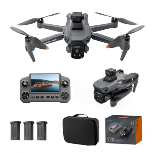
This drone combines a high-resolution camera with advanced LiDAR obstacle avoidance to support safer flights and precise navigation. The 360° LiDAR system, paired with GPS and optical flow positioning, helps maintain stability in complex environments. A 90° electric lens adjustment enhances framing and versatility for varied shoots. With a 5G display remote and three high-capacity batteries, users can extend flight times and monitor the scene in real time while ensuring safe returns via the multi-function GPS return feature.
Key considerations: LiDAR performance for obstacle avoidance, flight time, and ease of integration with existing ground control software. This model suits enthusiasts seeking a ready-to-fly experience with robust sensing and robust telemetry capabilities.
Benewake TFmini Plus LiDAR Module

The TFmini Plus is a compact, high-precision LiDAR module designed for drones, robotics, and industrial automation. It measures distances from 0.1 m to 12 m with typical accuracy within ±5 cm (0.1–6 m) and ±1% (6–12 m). Its flexible interfaces (UART, I2C, and I/O) enable easy integration with Arduino, Raspberry Pi, and other controllers. The IP65-rated enclosure and sturdy ABS+PC construction make it suitable for outdoor and harsh environments, supporting reliable sensing in real-world drone operations.
Use cases include autonomous navigation, obstacle sensing, and distance measurement in tight airspace. Consider compatibility with your flight controller and whether you need single-point TOF sensing or multi-sensor fusion for more robust SLAM systems.
youyeetoo FHL-LD19 Lidar Sensor Kit

The FHL-LD19 LiDAR Kit provides 12-meter ranging with 360-degree silent scanning, powered by a brushless motor for reliability and long life. It includes ROS/ROS2/C/C++ SDK access and a Raspberry Pi tutorial, facilitating integration into drone SLAM workflows and autonomous mapping projects. Resistance to bright light enhances performance in sunny outdoor environments, making it a versatile choice for field operations and indoor-outdoor transitions alike.
When selecting a LiDAR kit for drones, consider mounting compatibility, data interfaces, and software support for your preferred autopilot or computer vision stack. The kit’s 12 m range and full-circle scanning support robust environmental sensing for precise navigation and mapping tasks.
Stemedu TFmini-S Lidar Sensor
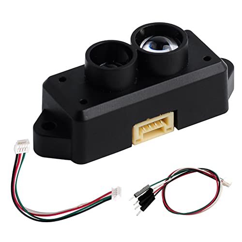
The TFmini-S is an optimized micro-ranging module suitable for drones, Arduino, and Raspberry Pi projects. It uses the Time-of-Flight principle to deliver stable, precise distance measurements across 0.1–12 m, with a focus on high sensitivity and fast response. With UART as the default interface (I2C option available), it remains a popular choice for Pixhawk-based flight controllers and other autonomous platforms seeking compact LiDAR sensing without heavy processing requirements.
Key decisions include whether to prioritize compact size and weight, or higher data throughput for complex SLAM tasks. The TFmini-S fits well in lightweight drones where simple obstacle avoidance or distance sensing is required in conjunction with other sensors.
youyeetoo TF-Luna Lidar Sensor Kit

The TF-Luna kit is a single-point LiDAR solution with a 0.2–8 m range, designed for easy MCU integration and development. It includes a USB-TTL adapter, making it straightforward to connect to development boards such as Arduino or Raspberry Pi for drone obstacle avoidance, mapping, and other sensing tasks. This kit is well-suited for hobbyists and researchers building custom flight stacks or experimenting with LiDAR-assisted navigation.
When selecting a LiDAR sensor kit, evaluate your required sensing range, target environment (indoor vs. outdoor), and compatibility with your existing flight control software. The TF-Luna’s affordability and developer-friendly interface make it a practical starting point for LiDAR-enabled drone projects.
Buying Guide: Key Purchase Considerations And Comparisons
- Intended use and workflow: Determine whether you need integrated LiDAR in a ready-to-fly drone or a standalone sensor kit for custom builds. Full drones simplify setup, while sensor kits offer flexibility for existing platforms.
- Range and field of view: Compare ranges (0.1–12 m, 0.2–8 m, etc.) and 360-degree scanning capabilities. For mapping and autonomous navigation, wider FOV and longer range can improve performance in cluttered spaces.
- Interfaces and compatibility: Check UART, I2C, SPI, and USB-TTL support. Ensure compatibility with your flight controller (ArduPilot, PX4, Pixhawk) or development environment (ROS/ROS2, Raspberry Pi, Arduino).
- Enclosure and ruggedness: IP ratings (IP65, etc.) and physical durability matter for outdoor use and dusty or wet environments. Weight and power consumption also affect flight performance.
- Software support: Look for ROS/ROS2 compatibility, SDKs, and tutorials. Strong software support reduces integration time and helps with SLAM and autonomous navigation.
- Power and flight time: For drones with integrated LiDAR, ensure the LiDAR’s power draw aligns with the aircraft’s battery capacity to maximize flight time.
- Cost and upgrade path: Consider total cost of ownership including accessories (adapters, cables) and potential future upgrades to improve sensing capabilities or expand to multiple sensors.
- Environmental performance: Bright light resistance, wind tolerance, and vibration resistance affect real-world reliability. Indoor vs. outdoor operation considerations differ significantly.
Bottom line: If you want an all-in-one platform with built-in obstacle sensing and camera features, a drone like the Zoiskn option offers convenience and integrated LiDAR. If you prefer modularity or a budget-friendly route to LiDAR-enabled projects, standalone modules like TFmini Plus, TFmini-S, and TF-Luna provide scalable options for development and experimentation. When building a robust LiDAR system for drone navigation, assess interface compatibility, software ecosystems, and environmental resilience to ensure reliable performance in the field.