Best Drones for 3D Mapping From Beginner to Professional Options
Exploring terrain, buildings, and landscapes in 3D requires drones with precise imaging, reliable sensors, and solid mapping software compatibility. The following picks are among the most capable for 3D mapping tasks, offering high-resolution imaging, thermal options, advanced stabilization, and long flight times. This guide helps you compare capabilities, from thermal mapping to photogrammetry-ready sensors, so you can choose a drone that fits your mapping workflow and budget.
Summary of chosen products:
| Product | Brand | Key Mapping Feature | Sensor / Camera |
|---|---|---|---|
| Autel Robotics EVO II Dual 640T V3 | Autel Store | Thermal imaging for data collection and analysis | 640×512 thermal, 50MP visible |
| Autel EVO MAX 4N V2 | Autel Store | Night vision + thermal + multi-sensor fusion | Thermal + 50MP wide + starlight camera |
| PK01 Drone With Camera (Screen on Controller) | X-shop Store | Easy flight for beginners; real-time image capture | 1080P camera |
| GPS Drones With Camera (4K, Foldable) | Generic | GPS autonomies for precise mapping routes | 4K camera |
| Foldable Drone With 1080P Camera | None | Budget-friendly aerial data capture | 1080P camera |
Autel EVO II Dual 640T V3 — Thermal Mapping Ready
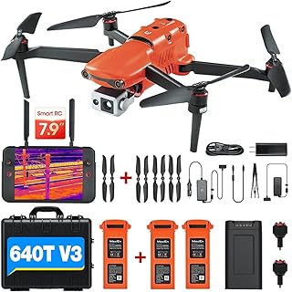
The EVO II Dual 640T V3 blends high-resolution thermal imaging with a sharp visible camera, making it a strong choice for 3D mapping projects that require thermal data alongside standard imagery. It features a 640×512 thermal sensor at 30 fps, a 50MP visible camera, and a 0.8-inch CMOS for detailed daytime mapping. With a robust flight platform and full warranty support, this drone supports accurate georeferencing and data capture needed for complex mapping tasks, inspections, and search-and-rescue scenarios.
Key considerations for mapping use:
– Thermal resolution supports hotspot detection and material analysis.
– The 50MP visible camera provides detailed orthomosaic inputs.
– Remote ID and safety features help with field operations in compliant environments.
– Data compatibility with common photogrammetry workflows (e.g., drone mapping software) is favorable.
Autel EVO MAX 4N V2 — All‑In‑One Sensing
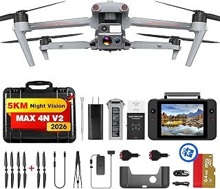
The EVO MAX 4N V2 adds a night-capable starlight camera, a high‑resolution 50MP wide camera, and a thermal sensor with a 640×512 resolution and temp measurement capabilities. Its 5KM night vision and triple anti-jamming design support reliable operations in challenging environments. The A‑Mesh 1.0 and hot-swappable batteries improve uptime, while robust obstacle avoidance helps maintain precise flight paths for mapping in low light or obstructed sites. This platform suits mapping teams that need round‑the‑clock data collection with resilient performance.
Key mapping considerations:
– Night vision expands field mapping in low-light conditions.
– Thermal and visible channels enable multi‑layer datasets for analysis.
– Hot-swappable batteries reduce downtime in the field.
– IP rating and rugged design support tough outdoor work.
Drone With Camera — Controller Screen Included

This beginner-friendly drone includes a built-in screen on the controller, enabling real-time viewing without a phone. The 1080P camera provides clear daytime mapping data, while the gesture controls and auto takeoff/landing simplify field use. Two batteries extend session time, and features like 360° flips and headless mode reduce the learning curve for first-time map makers. It is best suited for simple terrain surveys, aerial documentation, and introductory photogrammetry training.
Key mapping considerations:
– Real-time view without a mobile device speedily supports quick data capture.
– The 1080P camera is adequate for basic orthomosaic inputs and educational use.
– Gesture control and user-friendly modes shorten the setup-to-mapping cycle.
– Flight time is enhanced by dual batteries, increasing data collection opportunities.
GPS Drones With Camera (4K) — Foldable

This foldable GPS drone emphasizes mapping reliability with a strong GPS module, enabling automatic return and waypoint planning. The 4K camera (with a wide lens and adjustable angle) helps capture high-resolution imagery for photogrammetry workflows and 3D reconstruction. Long flight times and stable hold functions support methodical survey passes, while GPS features assist in precise geotagging and repeatable flight lines for consistent mapping outcomes.
Key mapping considerations:
– GPS Auto Return and reliable stabilization support consistent data collection.
– 4K imagery provides high-detail input for orthomosaics and 3D models.
– Foldable design improves transportability to field sites.
– Suitable for beginners and seasoned mappers seeking simple workflows.
Foldable Drone With 1080P Camera

This foldable option targets entry-level mapping needs with a 1080P camera and straightforward controls. It is a practical choice for beginner photogrammetry practice, small-site surveys, or educational demonstrations. Two batteries help extend data collection windows, while features like one-key start and gesture selfies make on-site use approachable for learners and hobbyists. It supports basic aerial mapping tasks and serves as a low-cost starting point for mapping training programs.
Buying Guide
- Sensor configuration: For 3D mapping, consider drones with high-resolution cameras (2D imagery for orthomosaics) and, if needed, thermal or multi-spectral sensors for specialized analyses. Thermal cameras add value in inspections and risk assessments but may require more processing time.
- Flight time and uptime: Longer flight times reduce the number of battery swaps and improve data collection efficiency. Hot-swappable batteries and quick-change options help in field missions with limited downtime.
- Georeferencing and accuracy: Look for drones with precise GPS/GLONASS positioning, stable gimbals, and data formats that integrate with photogrammetry software. Ensure compatibility with your preferred workflow (Metashape, Pix4D, DroneDeploy, etc.).
- Obstacle avoidance and safety: Active obstacle sensing reduces risk in complex terrain and improves data capture consistency in tight spaces or cluttered sites.
- Storage and workflow: Consider onboard storage capacity and transmission reliability. Real-time video and photo transfer should align with workflow needs, especially in remote areas.
- Regulatory compliance: Check local flight rules, including identification and airspace requirements. Some drones include remote ID to support legal field operations in many regions.
- Portability vs. capability: Foldable designs improve transportability, but larger platforms may offer steadier flights and more sensor options. Balance portability with desired mapping outcomes.
- Software ecosystem: Favor drones with robust software support for mission planning, automated flight paths, and seamless export of mapping data into your preferred processing suite.